
Surveying is an essential branch of civil engineering because it is the initial stage in initiating a new civil engineering project. A student must carefully study the fundamentals of surveying techniques in order to grasp them. To begin learning surveying, one must first understand what surveying is and why it is important.
Read More: What is civil engineering?
What is Surveying?
Surveying is the process of identifying the relative position of various features on, above, or beneath the earth’s surface using direct or indirect measurements and then recording them on a piece of paper known as a plan or map.
According to the American Congress on Surveying and Mapping (ACSM),
Surveying is the science and art of determining the relative position of points or physical and cultural elements above, on, or beneath the Earth’s surface and depicting them in a usable form, or establishing the position of points or details.
Types of Surveying
Surveying can be divided into two categories:
- Plane Surveying / Land Surveying
- Trigonometrical or Geodetic Surveying
Plane Surveying
Plane surveying is concerned with small areas on the earth’s surface, assuming that the land’s surface is plane. As a result, the curvature of the earth is ignored. Plane surveying can be further segmented as follows:
Chain Surveying
The survey area is divided into a number of triangles. The length of the sides is measured, and the internal details are written down. The whole is then plotted to a suitable scale on a drawing sheet to make the map.
Traverse Surveying
The plot of the plan is surrounded by a sequence of straight lines that form angles with one another To create the map, the lengths of the lines and angles are measured and plotted with details on drawing paper at a proper scale.
Plane Table Surveying
The observations and graphing are carried out concurrently. A piece of art paper or a sheet is placed on a plane table that has been calibrated. The field observations are made and documented side by side on paper before the map is created.
Ordinary Leveling
The altitudes of various sites on the earth’s surface are calculated. All elevation data required for construction activities is provided.
Geodetic Surveying
Curvature must be taken into account since geodetic surveying involves large areas. Geodetic surveying can be classified as follows:
Triangulation
On the survey plot, a network of well-defined triangles is established. One of the lines is designated as the baseline, and the other lines and angles are measured in accordance.
Reciprocal Leveling
Used to avoid instrumental errors when leveling across streams, gullies, and other obstacles. Level readings are made at two separate sites from two different setups. This survey determines the difference in levels between two sites with barriers.
Tacheometry or Stadia Surveying
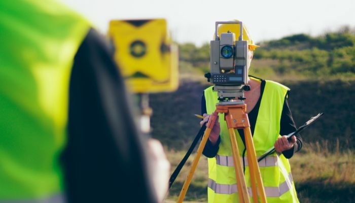
To measure distances, a telescopic sight apparatus is utilized. It includes a theodolite controlled by an operator and a level staff held at a distance by another surveyor. Stadia (the two horizontal markings on a theodolite) readings are used to calculate both vertical and horizontal distances.
Astronomical Surveying
Celestial bodies are used to determine the meridian, azimuth, latitude, longitude, and other coordinates of the plot to be surveyed.
Photographic surveying
Maps are created using photos acquired from appropriate camera sites, which can include airplanes. The end result is a map, drawing, or 3D model of a real-world scene or object.
Learn More What is Quantity Surveying
Importance of Surveying
Surveying knowledge is useful in many stages of engineering. Surveying is essential in any engineering job. Some of the fundamental significances of surveying are mentioned below.
- The first requirement for surveying is to create a plan and a section of the area that will be covered by the project. Based on these prepared maps and sections, the best potential alignment, quantity of earthwork, and other project-specific data can be computed.
- Surveying measures are used in the planning and design of all Civil Engineering projects such as railways, highways, tunneling, irrigation, dams, reservoirs, waterworks, sewage works, airfields, ports, enormous structures, and so on.
- During project execution, any size project is built along the lines and points determined by surveying.
- Land measuring and boundary establishment are impossible without surveying.
- A project’s economic and engineering feasibility cannot be fully determined without first conducting a survey.
- It is necessary to carry out hydrographic and oceanographic charting and mapping.
- Surveying is the process of creating a topographic map of the earth’s land surface.
Uses of Surveying
Below are a few of the numerous functions of surveying.
- Surveying is used to create topographic maps depicting hills, rivers, cities, villages, and forests, among other features.
- Surveying is required for the planning and estimation of new engineering projects such as water supply and irrigation schemes, mines, railroads, bridges, transmission lines, structures, etc.
- By surveying, a Cadastral Map depicting the boundaries of field houses and other properties is created.
- Through surveying, an engineering map depicting the location of engineering works such as roads, railways, structures, dams, and canals is created.
- To plan a project and transfer information from a map to the ground, surveying knowledge is required.
- Marine and hydrographic surveying are utilized for planning navigation routes and harbors.
- Surveying is used to create military maps that aid in strategic military planning.
- Exploration of mineral wealth requires a mine survey.
- Geological surveys are required for determining the strata of the earth’s crust.
- Archaeological surveys are utilized to unearth ancient relics.
Responsibilities of a Surveyor
A surveyor’s duties vary based on the type of surveying they undertake, however, some common responsibilities include:
- Measuring topographical characteristics such as depth, contour, and elevation.
- Using specialized equipment to collect data, such as total stations and GPS.
- Creating maps and written accounts of their findings.
- Collaborating with engineers, architects, and other professionals to ensure accurate and secure project completion.
- Resolving territorial disputes.
- Providing testimony as an expert in legal proceedings.
Surveyors must have the ability to work independently and as a member of a team, as well as communicate effectively with clients, other professionals, and the general public. Additionally, they must be able to operate in a variety of environments, including outdoors in all types of weather.
Usually, a bachelor’s degree in surveying or a related discipline is required to become a land surveyor. You must also pass a state-administered licensing examination in order to practice.
Learn More How to Become a Quantity Surveyor: The Ultimate Guide
Surveyors play an important role in many different industries, including construction, engineering, and land development. They play a crucial role in resolving boundary disputes and ensuring that construction projects are completed accurately and safely.
Additional responsibilities of a surveyor include the following:
- The research of legal documents, survey records, and land titles to clarify property boundary information.
- Creating and maintaining legal descriptions of surveys through sketching, maps, and reports.
- Verifying calculations and data.
- Keeping updated with survey results.
- Calculating the site’s measurements.
- Creating property-boundary descriptions.
- Supervising and providing direction to field personnel.
- The acquisition and maintenance of apparatus.
- Reporting survey results to clients and presenting findings.
- Multiple initiatives involving engineering and architectural collaboration.
Conclusion
In conclusion, surveying is a complex and essential profession that plays a crucial role in a wide variety of industries. Surveyors use specialized instruments and techniques to collect data about the Earth’s surface, and they use this information to create maps, plans, and other documents used to plan and construct buildings, roads, and other infrastructure. Surveyors are also responsible for resolving boundary disputes and protecting property rights.
Surveying is a difficult but rewarding profession that requires a solid background in mathematics, science, and engineering. Surveyors must have the ability to work independently and as a member of a team, as well as communicate effectively with clients, other professionals, and the general public.
If you are interested in a vocation in surveying, you have numerous options. You can become a valuable member of the surveying team with a solid education and the necessary skills.
Here are some additional considerations regarding surveying:
- The field of surveying is swiftly evolving, and new technologies are constantly being developed that allow for more precise and efficient data collection.
- Surveyors are in high demand, and the employment outlook for surveyors over the next decade is anticipated to be above average.
- Surveying is a rewarding profession that enables you to make a significant impact on the world.
If you are interested in learning more about surveying, there are numerous online and library resources available to you. You can also contact your state’s surveying commission for more information on how to become a licensed land surveyor.
FAQs
Triangulation: This technique involves connecting and overlapping many triangles to determine angles from a surveying station.
Trilateration: It employs the same concept as triangulation but with the addition of an Electronic Distance Meter (EDM).
Traverse: This approach connects many lines of pre-measured lengths to measure angles and distances.
Leveling: The difference in heights in terrain is assessed using graduated rods in this technique.
Radiation: Radiating lines are drawn from a focal point to defined bounds and translated to a small-scale surveying sheet in this approach. Surveying reveals several industrial uses in a variety of fields. It is an essential component of the Civil Engineering Discipline.
Surveying is the technique of determining the relative position of numerous places on the earth’s surface by measuring distances between them and creating a map to any suitable scale. Various surveying methods are founded on relatively simple core ideas. The surveying fundamental principles can be divided into two categories.
To locate the position of a point by measurement from two reference points
To work from whole to part
Surveying is a method for figuring out the relative position of points and the relative distances. It is essential in the subject of Civil Engineering. Surveying is useful in all civil engineering tasks. Surveying objectives vary based on the type of project. A surveyor must be clear about the aims of his or her survey. The primary goals of surveying are explored more below.
To evaluate the relative position of any objects or points on the earth’s surface.
To calculate the distance and angle between two objects.
To create a map or plan that represents a geographical area on a horizontal plane.
To create ways to use contemporary science and technology and to use them in the field.
To address measurement difficulties in the most efficient way possible.
Maintains records, creates reports, and writes correspondence regarding the work. Directs the development of survey maps, plans, and displays. Offers surveying expertise for unique surveying issues.